Wednesday, October 27, 2010

A look ahead, but what to believe?

For sure, one thing that has been learned over the past few years is that looking, simply, at a model run is not enough. One must look at the ensembles. The same model with little tweaks of data upon the initialization of the model run that allows for subtle changes and thus, different solutions. This will give you a better idea of what might happen by seeing where the bulk of the soltuions end up. But then, sometimes, like this example, who knows what to believe? This is a 204 hour solution of the GFS (about 8 1/2 days out) for North Ameria. On the left is the ensemble means (the average of all the possible solutions of this model.) The right shows the "spaghetti plot" which is to say it shows every model solution thus creating a thing that looks like spaghetti. The white line on the right is representative of the operational GFS model (one member of the ensembles.) The ensembles really don't agree well at all here and the GFS operational solution is an outlier! So, what will happen in 8.5 days? Your guess is as good as mine!!

Thank you to PSU's E-Wall for this set of images. The E-Wall (just google PSU E-Wall) is an awesome site!

Monday, October 25, 2010

The WRF vs GFS verdict. Who won? You be the judge?

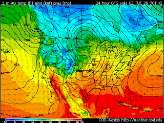
Well, all my previous blogs have led up to this moment. the WRF and GFS from 84 hours away to now have had different scenarios for the surface low. Now, this is not my analysis, done by hand, so there is some subjectivity done by the computer analysis program --- but --- you have to say the GFS was a little "closer" to being right, it would appear!  Meanwhile, this storm is BOMBING and is going to be just amazing as it intensifies over the next 24 hours. Wow!

the final installment. At 12 hours away, WRF vs GFS


Clearly, even at 12 hours away, there are still differences but there is finally some continuity b/t the models. Now we shall see if either one of them are right at 00Z Tuesday (7pm, tonight). 

Meanwhile, this storm system will be something else. by 00Z Wednesday (7pm Tues Night), the surface low will have "bombed" with pressure falling to the low 960's in millibars. That's Cat-3 Hurricane type pressures!

More on that with upcoming blogs.

Hope you enjoyed the last 3 days of watching the models :)

Sunday, October 24, 2010

24 hours away, WRF vs GFS in an epic battle for who is right. :)


To know what this is..see my previous few blogs, but, we are 24 hours away from 00Z Tuesday now and the WRF and GFS still can't get along. Unreal. Like two stubborn young bothers and neither will give in!

36 hours away, can the WRF and GFS agree? Hmmmmm


The GFS has continually had the surface low near ND/SK/MB while the WRF has had the sfc low near KS. Here we are 36 hours away and we finally see some agreement. They now show *both* areas of low pressure, to some degree. Be sure to check the previous 4 posts on this thread to see the progression of both models. It has been interesting to see how they have come together. But, one can see that there are still plenty of differences in the details. 

On thing for sure, which I haven't mentioned, is that there *is* a monster storm coming into the northern/middle part of this country and into the Great Lakes. "Edmund Fitzgerald" type storm is a comin'!  I've been showing the models valid 00Z Tuesday (7pm Monday night) but a look at what is coming in the Monday-Wednesday time frame is rather amazing.  

Once we get to Tuesday, I'll show an analysis to see how the models really did and which one was correct, but also to show this major storm.

48 hours away, Can WRF and GFS agree? NOPE! :)


Now only 48 hours away, the WRF and GFS still can't agree on the location of the surface low and the overall surface pattern. From an air-mass standpoing, they are basically the same but the resulting areas of convergence (rising air) and frontal locations are going to play havoc with forecasters, if they choose to just play the numerical model dartboard game.  (See previous few entries for the progression of this thread.)

Saturday, October 23, 2010

The WRF vs GFS saga continues ...


This is the 3rd installment of WRF vs GFS. We are now 60 hours away from 7pm, Monday night (00Z Tuesday). I've posted what the 84 hour prog was, then the 72,  and now this. I continue to watch this vastly different scenario unfold in regards to where the surface low will be. The WRF now has the surface low southeast of Lexington, NE while the GFS has now settled on North-Central ND. See my previous two posts to see the previous solutions.

WRF vs GFS: The battle continues. Now we are 72 hours out ..


My previous post detailed this same time period, a forecast valid for 00Z Tuesday (or 7pm Monday night). My previous post showed the GFS and WRF 84 hour forecast. Now, this is 12 hours later (or 12 hours closer to the valid time) and we see the GFS and WRF still having a huge difference in the placement of the surface low. The WRF has moved now a bit further south with it's solution while the GFS kept the surface low a bit further west. There is enough variability run to run among the same model to make those in the Plains get nervous about how to forecast this, but add to that the model-to-model differences and I can only pitty the zone forecaster sitting in the Plains trying to decipher this. Currently analysis leads me to believe the WRF is far more accurate. We shall see! :)

Friday, October 22, 2010

Would you believe the WRF or the GFS?


Something tells me that a surface low in Kansas vs a surface low in Manitoba will yield some different results! This is the 84 hour forecast from the WRF and the GFS valid 00Z Tuesday. Clearly, a large system is coming into the plains -- that is easily seen on satellite with a jet coming in around 40 degrees latitude. This will be a transitional type system taking us from this continued mild and sunny pattern to a more late fall/early winter type weather. However, it is clear that the models are having an issue with the details (and that is an understatement!!)

Saturday, October 2, 2010

The first lake effect of the season. Today it is rain but in the next coming weeks this will become snow showers. Cold air moves over the summer-warmed lake waters and creates an unstable air mass. Air rises quickly from the warm water to the cool air above resulting in numerous showers. With temperatures in the low 50's, winds gusting to well over 30mph, and a cold rain, there is no question that autumn is here!


Friday, September 24, 2010

Fall is here!

Well, after 3 days of warmth, including 2 that were around 90 here in late September, along with plenty of high dewpoints -- Fall has arrived! Today is cloudy, windy, and cool. The first real fall weather type day. With the equinox now in our rear view mirror, the sun has set on the north pole. Light is very limited north of the Arctic Circle and things will only go downhill from here. Before we know it, the junk we know as snow will invade our lives.

Tuesday, September 21, 2010

September Squall Line


 Sept 21st, the day before the start of Astronomical Fall, or the Equinox, a healthy (and severe) squall line approaches NE IL from Iowa. Taking on a bit of a "bow" shape, as severe winds push this squall line towards us. Reports of Semi's being pushed over and power lines down have been pretty common so far. The shear (how the winds change with speed or direction as you go up in height) is not conducive to tornadoes today but for winds and heavy rain, it sure is.

I love our atmosphere!


Monday, September 13, 2010

Lake Breeze 09/13/10

Even though the winds are generally west-northwesterly, there is enough temperature difference between the water and land, as well as enough northerly component of the wind, to allow for a lake breeze in Chicago today. That enhanced line of echoes that runs north-south, parallel to the Lake Michigan shoreline, is the edge of the lake breeze, itself.

Friday, September 10, 2010

Welcome!

Well,  my name is Matt Powers. I work for the College of DuPage Meteorology Dept (NEXLAB), mostly as the Storm Chasing Asst, managing the webpages, organizing case studies, and basically supporting the program in any way possible. I plan on using this blog to update things on the weather, give my opinions on anything that might pop up, talk about my travels, and discuss my favorite food. :)  It will be about 80% weather and 20% other things, I would suppose. I hope you all enjoy!

http://weather.cod.edu/